
In September 2023, seismometers around the world registered an unknown seismic signal that was visible in places for up to nine days. It was caused by a massive landslide in the Dickson Fjord in Greenland. Researchers from all over the world discovered that the source of the vibrations was the continuous sloshing of water back and forth in the narrow fjord. They also proved that the landslide was linked to the thinning of a glacier. Both are due to climate change. Their findings have been published in the journal Science. In future, the researchers want to monitor the Dickson Fjord in order to provide early warning of landslides and tsunamis.
A year ago, seismometers around the world seemed to be going crazy. “In September 2023, we discovered a signal that could be detected worldwide,” says Dr. Thomas Forbriger from the Geophysical Institute of KIT. “It looked completely different from an earthquake. The signal was characterized by a persistent oscillation with a single dominant frequency, resembling a monotonous hum that gradually fades away."
In an effort to understand the phenomenon, 68 researchers from 40 institutions in 15 countries and various disciplines joined forces. "Thanks to this interdisciplinary collaboration and the unique combination of local data and global remote observations, we were able to reconstruct an extraordinary sequence of events,” explains Forbriger. “Measurement data of the quality recorded by KIT and the University of Stuttgart at the geoscientific Black Forest Observatory has made an important contribution to this.”
Reconstruction of the event using mathematical models
The researchers combined seismometer and infrasound data, field measurements, ground and satellite images, simulations of tsunami waves and images from the Danish military to create a realistic high-resolution numerical model of the remote Dickson Fjord in Greenland. With this model, they were able to reconstruct the event and prove the cause of the signal.
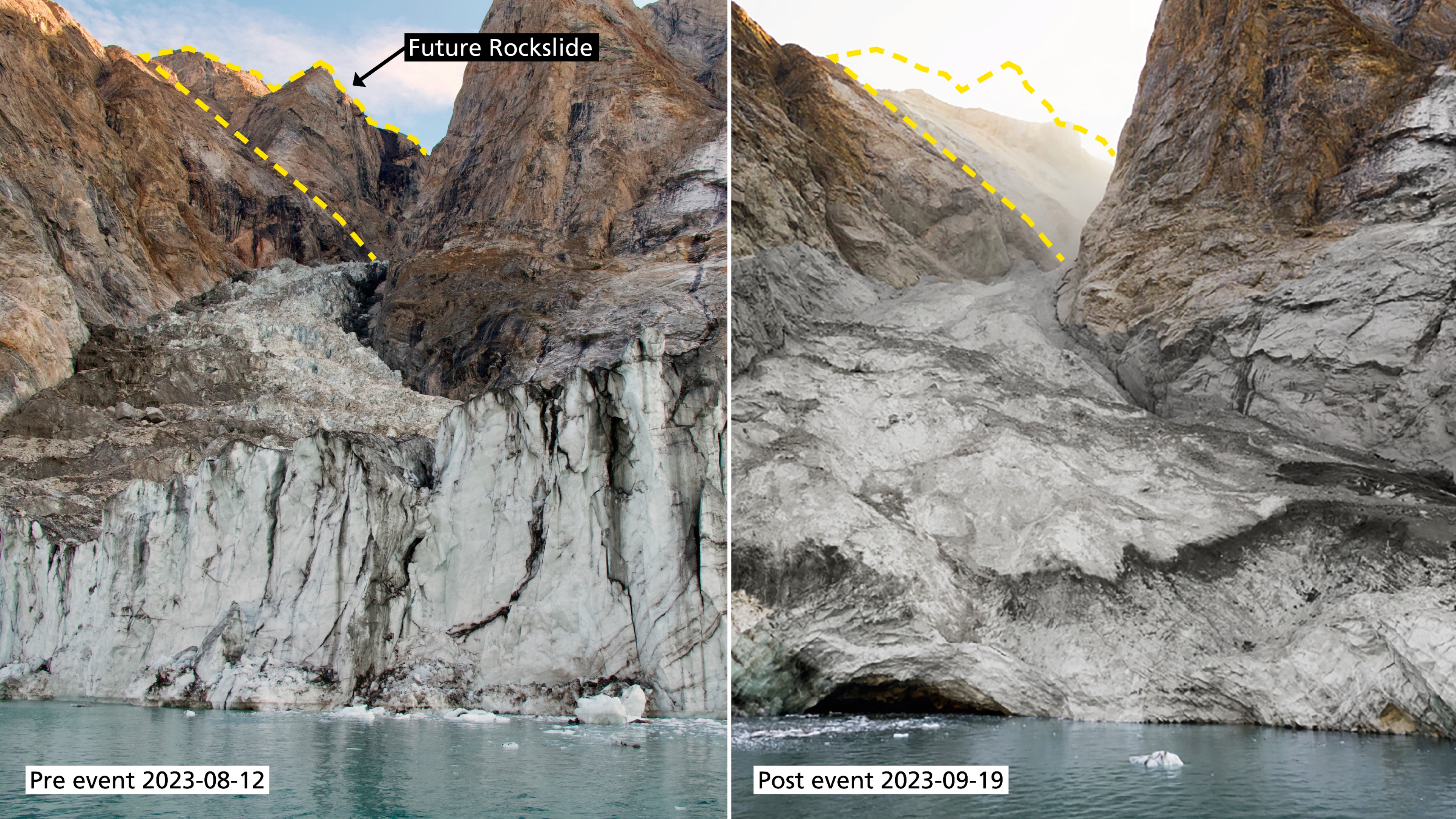
The model revealed that a so-called seiche - a phenomenon similar to water sloshing back and forth in a bathtub - was responsible for the oscillations that could be measured all over the world. It was created by a massive landslide in the fjord, which was caused by a collapsing mountain peak that previously rose 1,200 meters above the fjord. “The volume of falling material was enormous - more than 25 million cubic meters. That's enough to fill 10,000 Olympic-sized swimming pools,” says Kristian Svennevig from the Geological Survey of Denmark and Greenland (GEUS), who coordinated the research. The falling mass displaced a large volume of water, which excited the fjord as an initially 200-meter-high megatsunami. The waves created by the event, which lasted only a few minutes, sloshed back and forth in the narrow fjord for days.

Seismic waves generated by the movement of large water masses
The researchers' calculations revealed that the water oscillated back and forth across the fjord with each phase lasting approximately 90 seconds, matching the oscillation period of the recorded seismic waves. “The fact that it is capable of generating such a vibration seems to be a special characteristic of the Dickson Fjord. In scientific literature, there are almost no documented cases of sloshing oscillations with such a low frequency that fade so gradually. Our observation is also unique in this respect,” emphasizes Rudolf Widmer-Schnidrig from the Institute of Geodesy at the University of Stuttgart.
The movements of this large water mass generated seismic waves that were measurable at the nearest measuring stations for over nine days. The waves went around the earth and could be observed as far away as Antarctica, almost 20,000 kilometers away. According to the study, the tsunami was one of the highest in recent history. Outside the fjord, four-meter-high waves damaged a research base on the island of Ella, 70 kilometers away, and destroyed cultural and archaeological sites throughout the fjord system.
Links between climate change and geological processes
The researchers also investigated what triggered the massive landslide. Satellite images show that the glacier at the foot of the mountain has thinned out considerably in recent decades. The landslide and tsunami were also the first to be observed in north-east Greenland. The researchers attribute the event to climate change, demonstrating that this is already having a strong impact there too.
The researchers are planning to install seismic instruments in the Dickson Fjord to gain an even better understanding of the area. "We were lucky that no people were injured in this incident. But our research shows that in the face of rapidly accelerating climate change, it will be more important than ever to characterize and monitor regions that were previously considered stable,” says Svennevig. “This is the only way we can warn of such massive landslides and tsunamis in good time in future."
Original publication
Kristian Svennevig et al.: A rockslide-generated tsunami in a Greenland fjord rang the Earth for 9 days. Science, 2024. DOI: 10.1126/science.adm9247
Text: Sandra Wiebe, KIT
Our "Publications compact" series presents further news about research findings from Stuttgart publications in a clear, concise, and accessible way for everyone.

Jacqueline Gehrke
Online Editor